Photo: Nancy Stone/Chicago Tribune
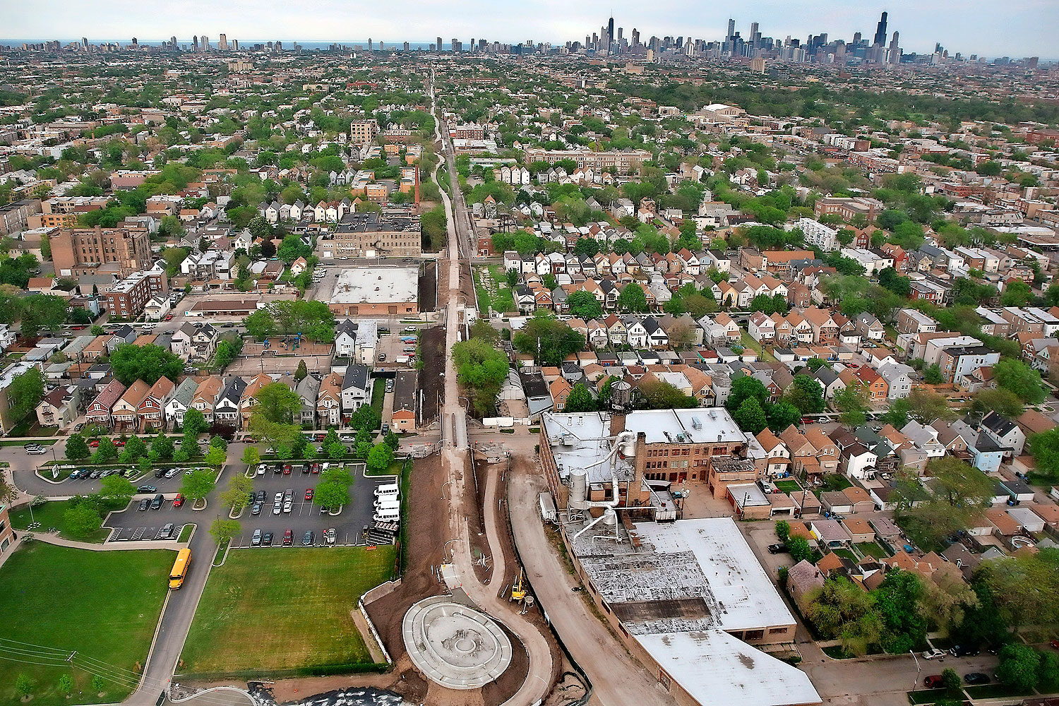
"If you understand this as a relic of another era, our job is to transform this into something else, and in so doing, turn cultural heritage into cultural futures." Frances Whitehead says this while sitting in her studio, which is carved out from her home, which was carved out from an industrial building. Light floods in through a small, verdant courtyard encased by glass. Models and renderings of the 606, the new elevated park running through four neighborhoods on Chicago's northwest side, cover the floors and walls. A couple miles north, that transformation is happening as bulldozers and backhoes translate the ideas in her head and studio into a 2.7 mile-long, $95 million corridor.
"What is the culture of that future? What kind of culture will get us to that future?" Whitehead says. "I think of the 606 as a transportation corridor, it's a connector, but it's also a linear story, or a linear mechanism to get us from where we are into the future."
Advertisement
You can tell the story of Chicago, the city in a garden, from its parks. One of the main features of the 606, the Humboldt Overlook, invites visitors to sit and contemplate that history in the form of Humboldt Boulevard, part of a massive network conceived by Daniel Burnham and designed by William LeBaron Jenney, builder of the world's first skyscraper. Burnham conceived of his City Beautiful to "tame Chicago's anarchic complexity" with European grace. Jens Jensen, who designed Humboldt Park itself, wrestled Burnham's grand vision into a wild, populist, American vernacular. Jensen's protege Alfred Caldwell, a student of Frank Lloyd Wright and a colleague of Ludwig Mies van der Rohe, brought Wright's Prairie Style to Promontory Point and Jackson Park. Lurie Garden in Millennium Park frames its prairie style within an international urbanity, courtesy of Dutch landscape architect Piet Oudolf, a cosmopolitan park for a Midwestern city striving to hang on as a world metropolis. Jeanne Gang's concept for Northerly Island updates Jensen's nativist conservation with the latest understanding of environmental science.
But what stories will the 606 tell?

I.
Like its predecessors, it will tell a story of urban environmental anxiety, with a living data visualization that runs the length of the park, an ongoing experiment in climate science. Serviceberry trees will burst into bloom every spring, but the cooling effect of the lake ensures that it happens gradually over the course of several days, like lights turning on down a long hallway as the city slowly comes back to life.
It will mark the change in the seasons. But also the change between seasons, as their budding preserves a record of temperatures.
"A few years ago, I had been at the German weather service, the Deutscher Wetterdienst, and I encountered this idea of phenology, using bud burst and bloom time as a climate indicator," Whitehead says. "They had really put that on the map in terms of re-introducing that into the world community, but there was nothing in the United States."
Whitehead began collaborating with Mark Schwartz, a phenoclimatologist at the University of Wisconsin-Milwaukee and cofounder of the USA National Phenology Network (USA-NPN), who provided her with the scientific foundation for her phenological installation.
"Without some real data, this wasn't going to happen," Whitehead says. "He put together a big scientific study using existing weather data from two weather stations; they're the same distance in from the lake, the same distance as the beginning and the end. He crunched the data and came up with this idea of the, on average, five-day bloom spread. He looks at the cumulative degree days, and from one end to the other, the minimum and maximum average degree days. What happens is that, on a given day, the temperature out there is only two degrees difference from there to there. That doesn't seem like much, but if you add it all up, it's two degrees today, and three degrees tomorrow, and one degree the next day, after the whole winter, you start to see the difference in degree days is cumulative, and the plants will respond to this difference."
Advertisement
There's an even longer precedent for this that Whitehead is drawing from with the phenological work—the Japanese cherry blossom festival, which has been celebrated in Kyoto and surrounding towns at their flowering since the 9th century. Recently, Japanese scientists have used that historical record to generate 1,200 years worth of climate data. It's an organic parallel to the Array of Things, the open-source environmental sensors proliferating throughout Chicago.
"They've been keeping the records of when the cherry blossoms bloom, because they're so important culturally, not scientifically," Whitehead says. "But this enormous data set has turned out to be the best climatological data set that we have, and it was generated by culture. It was generated by the appreciation of beauty. It was not generated by science, and not generated, certainly, by social responsibility. So I'm like, this is so interesting, could we replicate that? My politics are, we need people to tune into where they live, tune into the realties of place, appreciate the lake, consider the possibility of climate change. You might say I'm looking for interesting ways to do a new kind of environmental education."
The serviceberries lining the trail will mark the days and the weather; clumped along side them will be plants to translate that data into other contexts, mathematical constants come to life.
"We have Chinese Lilac—Red Rothomagensis," Whitehead says. "It's a specific cultivar. This is a plant that's being used as the USA-NPN as their calibration species. That has to be here to compare our system to another system that is built with a different plant. If they want to compare serviceberries to oak trees, they have to have a comparative something that links the data sets. They're using the lilac, because there was a lilac program established in the '70s, and they have what they call legacy data. There's old data going back to the '70s based on lilacs, and they want to use that data. It was chosen originally, even though it's not a native, because it will grow in all 48 states. They can use the lilac as the linkage to compare apples and guavas. They can cross-reference the data. These are planted along the way as calibration.
"Illinois uses the forsythia—a non-native, but it's in the landscape—it's a calibration species for the state of Illinois. The landscape architects wanted to use the forsythia at all of these bridges. They're using a weeping forsythia that kind of spills down as a kind of signage to people below to know there's a green space. What that does, is it creates a kind of mapping with these yellow forsythia.
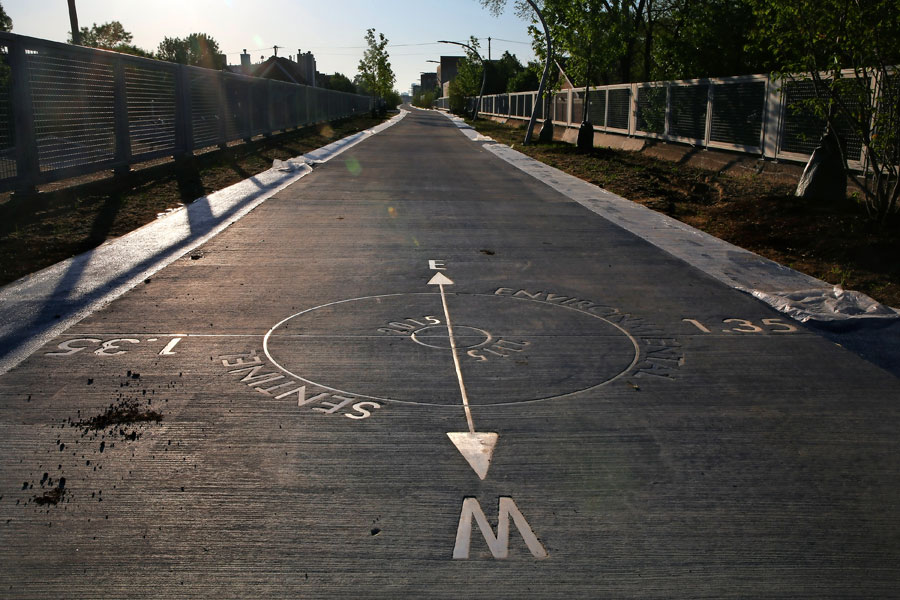
"According to the phenologic scientists, this planting will allow them to see climate as a continuum in time and space. Not just through the days of the spring, but actually spatially as well as timewise. It's a very unique opportunity and a really important device." Measuring off the distance between the phenologic plantings, crucial to get spacial data, are mile markers, every tenth of a mile along both sides of the path, which serve a second purpose.
"Runners wanted mile markers," Whitehead says. "So I thought, this is perfect—the mile markers can also be used by the observation program to help navigate towards the trees, to create a kind of division, like graph paper, that provides a system for keeping track of all of this data… a scientific instrument, a big calibrated ruler." As runners whiz by, checking their watches or pedometers, scientists will follow slowly behind, marking a collective form of fitness.

II.
The 606 will also tell its own story—an industrial corridor abandoned and turned feral, rediscovered by urban explorers, and transformed into a stylized urban amenity, like the exposed-brick lofts in its wake.
"We were taken by the found-objects quality of the rail line," says landscape designer Matthew Urbanski, a principal at Michael Van Valkenburgh Associates, the Brooklyn firm that served as lead designers. "Big massive walls and the bridges and all that. We wanted to come up with something that was very authentic in terms of the industrial past, but at the same time, transformative. Something that allowed that to read through, the strength of that, but converting it into a public park as well."
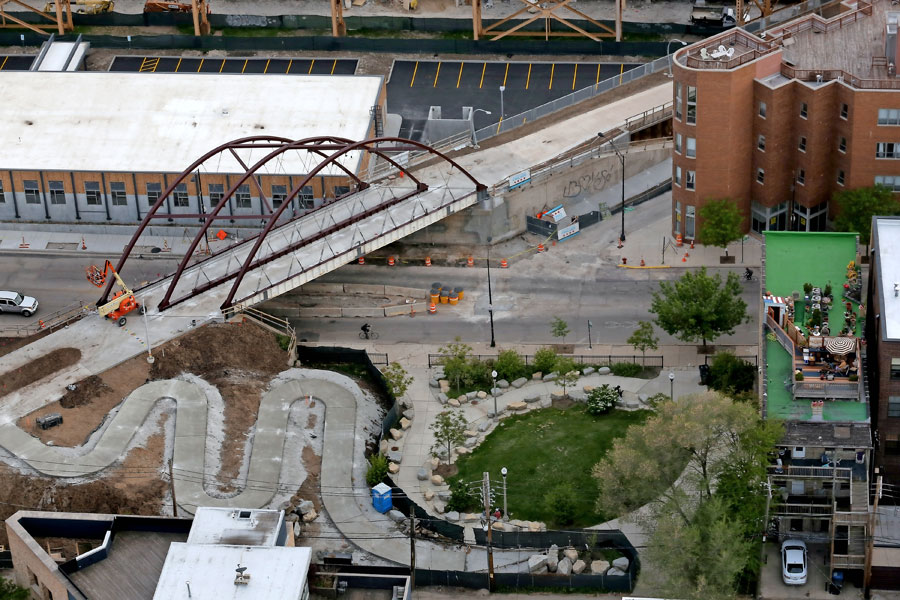
Urbanski and his colleagues were greeted by a flat plane running through the city, "relentlessly the same." They re-graded the path to dive down between the thick, pitted concrete walls, adding topographical variation for variety, and to slow down cyclists who might have been tempted to treat it like a drag strip. Changing the grade changed its nature, which changed the possibilities for landscape design. (Much of the fill was used to build the spiraling observatory at Ridgeway Avenue, the western trailhead, which will mark the winter and summer equinox.)
Advertisement
"What that did was give us ups and downs, revealing the walls, and that worked nicely with the found-object quality in revealing the structure. It also started to vary the environment, literally, of the trail. You had different kinds of conditions, sloped conditions, high conditions, low conditions," Urbanski says.
"One way of looking at the top from an ecological perspective is that it was very consistent to begin with, and by varying the grades, we started to vary the ecology of the top. That led to the idea that for a whole three-mile walk or bike ride, it would be nice to have some variety of planting along the length of it. And it could start to respond to these different conditions that are created. Then we could make additional variety along that length, really taking inspiration from prairie landscapes, what is growing well in the neighborhood, and starting to think creatively about those kinds of things, start to generate different kinds of feelings as you move along.
"There are moments where the planting is very distinctly different. There are themes that happen: at the entrances, there are access parks. One of the things we did was incorporating a lot of tall evergreens at those points, that we were calling the entry sentinels. That reoccurs as a theme. Something else that reoccurs as a theme is a kind of underlay of grasses, or grassy-feeling plants that can move from shade to sun and give a kind of continuous grassy carpet, a native-grass feel to the ground plane.
"If you listen to the great symphonies, there's a theme, and then it's reiterated in different ways, and then there's things overlaid on top of it. Sometimes you can do that, and in a linear park, it's a little bit like a musical score."
The full effect of the landscape design will not be apparent as it opens; many of the plantings are yet to come in, and many of the trees that are there are still mere saplings. As the rail line evolved into an urban prairie, the 606 will mature from a somewhat sparse active-transportation corridor to a verdant park. Sumac trees will rise and spread to form an "arbor effect"; trembling aspens will grow to shade the trail.
"Because of the work that we needed to do, we couldn't keep very many, hardly any trees that had spontaneously grown up there. But there is an intriguing kind of poetry to industrial artifacts that have been taken over by nature," Urbanski says. "There's an interplay between nature, you can see this slow-motion dance going on where there's an interplay between nature and the object. We're very interested in that. The planting was done through that lens. How is that going to evolve? How are people going to perceive this over time? It's not so much a set piece, in other words, but a dynamic relationship we're trying to create, that seems to be more about the passing of time, impermanence and permanence. That seems to us to be more authentic, too. There was a kind of feral quality to the top that, in a positive way of looking, at it was interesting, and in a negative way, abandoned and scary. I think what we're trying for is a designed version of that."
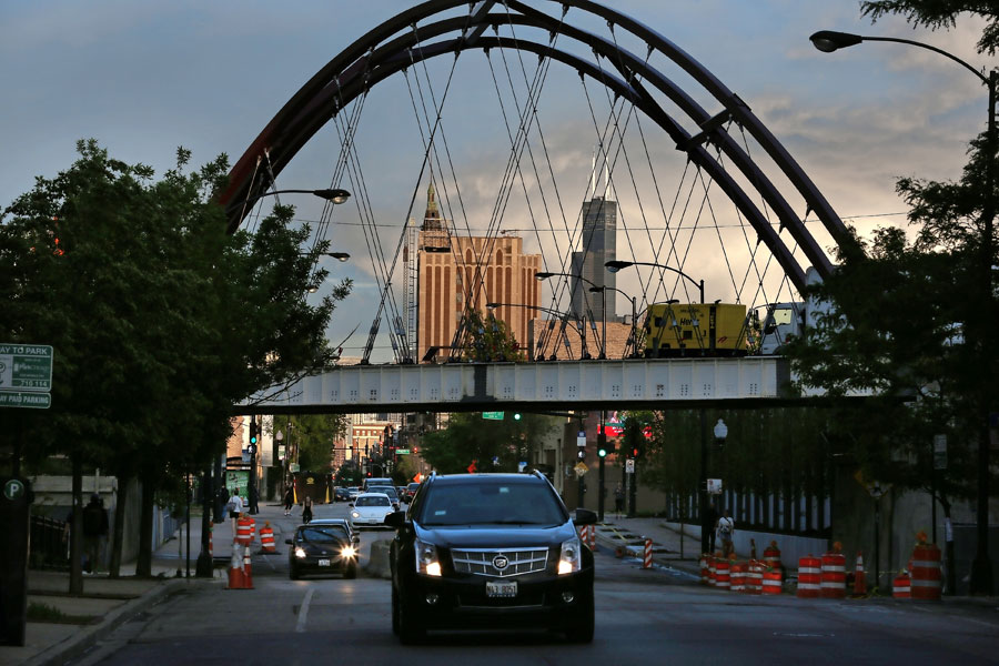
At Milwaukee Avenue, where an arched bridge has served as the public centerpiece to the park during its construction, that story is told horizontally instead of vertically. Dolomitic limestone boulders—from the formation that underlies Chicago, the limestone that architects Walter Netsch and Bruce Graham used as an anchor for their Inland Steel Building in one of the city's herculean efforts to rise above the swamp—lead up towards the trail. Narrow fastigiate trees lead the eye up past the old industrial train line to the highest point of the El; above the whole scene is a billboard that's been repurposed for artwork. When the trail opens, Kay Rosen's sunny textual work Hi will greet visitors with its titular message.

III.
And the 606 will tell the story of its neighbors, and what they want the trail to say. "It was like a Rubik's Cube, but linear, like moving the cars of the train around," Whitehead says. "A big, integrative puzzle, responding deeply to hundreds of details from communities."
Sometimes those responses will be subtle. Lots of people, Whitehead says, wanted an actual train car on the path, but its narrowness eliminated that idea. No one liked the idea of just leaving one in a park. Eventually, that request turned into the Observatory at Ridgeway, looking west towards the Metra tracks.
Advertisement
"We realized that there are live trains every day," Whitehead says. "So the soil comes down here and becomes this spiraling earthwork. I'm looking at it, and going 'oh, that looks like it's almost lined up at the solstice.' I go down to the Adler Planetarium, talk to them about the angle, and this mound becomes two things. It becomes an observatory for seeing the winter and summer solstice equinox events, but it also provides, every other moment, a lookout onto live trains."
At the equinoxes, it's a place to observe the change in seasons; in between, for the more contemporary pastime of trainspotting.
On one end, the 606 is a place to watch mass transit. On the other (once/if it is funded), at Walsh Park on Ashland, will be a place to watch more individualistic forms of transportation.
"[The city] started building skate parks underneath the expressways because of the noise," Whitehead says. "But we interviewed members of the skate community, and they hate that. They feel like they're being shoved to the margins, they're ghettoized… what, nobody wants to see a bunch of teenage boys? [Ed. note: Not everyone, no.] It was interesting to think about the fact that, even though they're usually sequestered, the skating community was not happy about that. They like plaza-style—in other words, skating through the city, and being in the city like everybody else."
Towards the other end of the trail at Kimball Avenue, and like the Walsh Park "wheel-friendly event plaza," as yet unbuilt, a park is planned with a "Learning Garden" and "Learning Zone Plaza." Parks have always balanced leisure with moral uplift, and the community desire for an educational component led to the Kimball Park plan. What resulted hearkens back to an old idea of Jens Jensen, "municipal kitchen gardens where local residents might raise their own food and sell it… amenities and variety that the middle class were by then fleeing to the suburbs to find." Which, of course, is a very contemporary concern as well."The people wanted engaging, educational, interesting things for their children, who they felt would benefit from an educational component. So we created this learning garden and proposed a participatory orchard because of the question of urban agriculture," Whitehead says. "It's a symbolic orchard, a sculpture. It'll probably produce fruit, but not enough to go around. But it poses the question: what should be in our public parks? Because a lot of people said, 'this should be a community garden!' And then people would say, 'this isn't a community garden, it's a bike path.' And we're, like, but we have to think about our food, so why can't it link to community gardens? So here's this symbolic orchard, that also creates a shaded amphitheater you can sit under and look down at the plaza. The landscape architects chose these psychedelic plant materials here to be super-engaging for kids. Really weird, wonderful plants."

That's the 606, so far. It will open on 06/06; it won't be complete. In the short term, more plantings will be done; that green which does not grow on trees is needed to complete more of the plan. In the longer term, the plants will grow; in a longer term still, those plants will generate data, which will become patterns, which generations far down the line will learn from, or not. It marks where Chicago is today, while generating an environmental history as the future turns into the past.
"I'm hoping that another, deeper kind of understanding of where we are, where we're going, and what's happening in front of us can evolve over a very long time. This question of the Japanese cherry blossom that did a certain thing—we won't know if this is a success before… we'll all be off the planet before we know," Whitehead says. "It's forming a hundred-year artwork. It's making a proposal that art doesn't have to deliver itself as an instant experience. It can become a hundred-year experience. That's the kind of timeframe this piece is imagined for, and we can experience it over a lifetime."


